


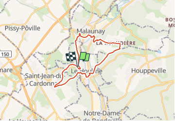
20240113-le houlme

doudet
User

Length
12 km

Max alt
143 m

Uphill gradient
260 m
Km-Effort
15.5 km

Min alt
30 m

Downhill gradient
268 m
Boucle
Yes
Creation date :
2024-01-13 12:35:22.283
Updated on :
2024-01-14 10:30:37.405
3h42
Difficulty : Medium

FREE GPS app for hiking
 SityTrail
IGN / Geographical institutes
SityTrail Plus
The world is yours!
About
Trail Walking of 12 km to be discovered at Normandy, Seine-Maritime, Le Houlme. This trail is proposed by doudet.
Photos


31 photos in total. Please click on a photo to see them all in the gallery.
Positioning
Country:
France
Region :
Normandy
Department/Province :
Seine-Maritime
Municipality :
Le Houlme
Location:
Unknown
Start:(Dec)
Start:(UTM)
357478 ; 5486141 (31U) N.
Comments